
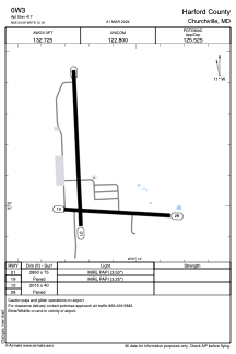


0W3 - Harford County
Located in Churchville, United States
ICAO - 0W3, IATA -
Data provided by AirmateGeneral information
Coordinates: N39°34'4" W76°12'11"
Elevation is 412 feet MSL.
Magnetic variation is -11° East View others Airports in Maryland
Operational data
Special qualification required
Current time UTC:
Current local time:
Communications frequencies: [VIEW]
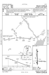
Runways:
| RWY identifier | QFU | Length (ft) | Width (ft) | Surface | LDA (ft) |
| 01 | 357° | 3353 | 75 | ASPH | |
| 19 | 177° | 3353 | 75 | ASPH | |
| 10 | 93° | 2015 | 40 | ASPH | |
| 28 | 273° | 2015 | 40 | ASPH |
Airport contact information
Address: Churchville United States
