
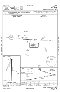


12G - Shelby Community
Located in Shelby, United States
ICAO - 12G, IATA -
Data provided by AirmateGeneral information
Coordinates: N40°52'22" W82°41'51"
Elevation is 1120 feet MSL.
Magnetic variation is -06° East View others Airports in Ohio
Operational data
Special qualification required
Current time UTC:
Current local time:
Communications frequencies: [VIEW]
Runways:
| RWY identifier | QFU | Length (ft) | Width (ft) | Surface | LDA (ft) |
| 03 | 25° | 1890 | 125 | GRASS | |
| 21 | 205° | 1890 | 125 | GRASS | |
| 18 | 179° | 3174 | 50 | ASPH | |
| 36 | 359° | 3174 | 50 | ASPH |
Airport contact information
Address: Shelby United States