
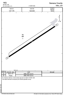


16G - Seneca County
Located in Tiffin, United States
ICAO - 16G, IATA -
Data provided by AirmateGeneral information
Coordinates: N41°5'39" W83°12'45"
Elevation is 786 feet MSL.
Magnetic variation is -05° East View others Airports in Ohio
Operational data
Special qualification required
Current time UTC:
Current local time:
Communications frequencies: [VIEW]
Runways:
| RWY identifier | QFU | Length (ft) | Width (ft) | Surface | LDA (ft) |
| 06 | 56° | 4000 | 75 | ASPH | |
| 24 | 236° | 4000 | 75 | ASPH |
Airport contact information
Address: Tiffin United States
