logo
Search for airport 
image banner adimage banner adimage banner ad
image banner ad

21ND - Rosenau

Located in Upham, United States

ICAO - 21ND, IATA -

Data provided by Airmate  

General information

Coordinates: N48°34'56" W100°51'17"
Elevation is 1450 feet MSL.
Magnetic variation is 10° East
View others Airports in North Dakota

Operational data

Special qualification required
Current time UTC:
Current local time:
Weather at : KMIB - Minot Afb ( 41 km )
METAR: KMIB 051857Z 00000KT 10SM SCT008 BKN100 22/21 A2995 RMK AO2A RAE55DZB55E57 SLP143
TAF: TAF AMD KMIB 051850Z 0518/0623 14010G15KT 8000 -RA BKN008 QNH2991INS BECMG 0519/0520 15010G15KT 9999 NSW FEW008 BKN080 QNH2989INS BECMG 0602/0603 16015G25KT 8000 -TSRA BKN040CB QNH2988INS BECMG 0604/0605 19012G18KT 9999 NSW BKN025 QNH2987INS BECMG 0608/0609 VRB06KT 3200 BR BKN005 QNH2986INS BECMG 0611/0612 26010G15KT 4800 BR BKN007 QNH2990INS BECMG 0612/0613 28015G25KT 9999 NSW SCT020 QNH2992INS BECMG 0615/0616 28015G25KT 9999 FEW020 QNH2991INS TX26/0522Z TN16/0512Z
View NOTAMs / SUP AIP / TFR affecting this airport [VIEW]
Communications frequencies: [VIEW]
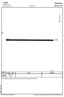
Runways:

RWY identifierQFULength (ft)Width (ft)SurfaceLDA (ft)
0890°250040GRASS
26270°250040GRASS

Airport contact information

Address: Upham United States

Satellite view of 21ND