


4M2 - Booneville Muni
Located in Booneville, United States
ICAO - 4M2, IATA -
Data provided by AirmateGeneral information
Coordinates: N35°8'58" W93°51'48"
Elevation is 468 feet MSL.
Magnetic variation is 05° East View others Airports in Arkansas
Operational data
Special qualification required
Current time UTC:
Current local time:
Communications frequencies: [VIEW]
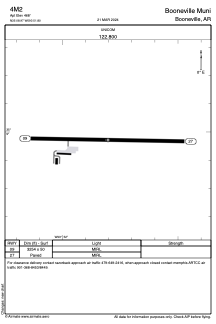
Runways:
| RWY identifier | QFU | Length (ft) | Width (ft) | Surface | LDA (ft) |
| 09 | 91° | 3254 | 50 | ASPH | |
| 27 | 271° | 3254 | 50 | ASPH |
Airport contact information
Address: Booneville United States