


51K - Cedar Air Park
Located in Olathe, United States
ICAO - 51K, IATA -
Data provided by AirmateGeneral information
Coordinates: N38°55'52" W94°53'5"
Elevation is 1024 feet MSL.
Magnetic variation is 05° East View others Airports in Kansas
Operational data
Special qualification required
Current time UTC:
Current local time:
Communications frequencies: [VIEW]
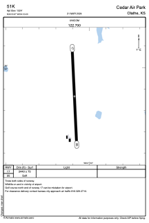
Runways:
| RWY identifier | QFU | Length (ft) | Width (ft) | Surface | LDA (ft) |
| 17 | 177° | 2440 | 75 | GRASS | |
| 35 | 357° | 2440 | 75 | GRASS |
Airport contact information
Address: Olathe United States