


7S8 - Ross Intl
Located in Sweetgrass, United States
ICAO - 7S8, IATA -
Data provided by AirmateGeneral information
Coordinates: N48°59'55" W111°58'42"
Elevation is 3553 feet MSL.
Magnetic variation is 18° East View others Airports in Montana
Operational data
Special qualification required
Current time UTC:
Current local time:
Communications frequencies: [VIEW]
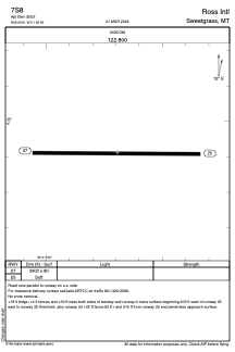
Runways:
| RWY identifier | QFU | Length (ft) | Width (ft) | Surface | LDA (ft) |
| 07 | 91° | 2900 | 80 | GRASS | |
| 25 | 271° | 2900 | 80 | GRASS |
Airport contact information
Address: Sweetgrass United States