


CAD4 - Trail
Located in , Canada
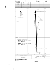
ICAO - CAD4, IATA - YZZ
Data provided by AirmateGeneral information
Coordinates: N49°3'36" W117°36'29"
Elevation is 1427 feet MSL.
Magnetic variation is 15.555° East View others Airports in British Columbia
Operational data
Special qualification required
Current time UTC:
Current local time:
Communications frequencies: [VIEW]
Runways:
| RWY identifier | QFU | Length (ft) | Width (ft) | Surface | LDA (ft) |
| 16 | 178° | 4800 | 75 | ASPH | 4499 |
| 34 | 358° | 4800 | 75 | ASPH | 4303 |
Airport contact information
Address: Canada