


CYBR - Brandon Muni
Located in , Canada
ICAO - CYBR, IATA - YBR
Data provided by AirmateGeneral information
Coordinates: N49°54'36" W99°57'8"
Elevation is 1343 feet MSL.
Magnetic variation is 5.6478° East View others Airports in Manitoba
Operational data
Special qualification required
Current time UTC:
Current local time:
Communications frequencies: [VIEW]
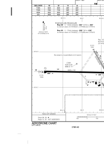
Runways:
| RWY identifier | QFU | Length (ft) | Width (ft) | Surface | LDA (ft) |
| 08 | 90° | 6510 | 150 | ASPH | 6510 |
| 26 | 270° | 6510 | 150 | ASPH | 6510 |
| 14 | 149° | 3068 | 60 | GRAVE | 3068 |
| 32 | 329° | 3068 | 60 | GRAVE | 3068 |
Airport contact information
Address: Canada