


CYFI - Firebag
Located in Fort Mackay, Canada
ICAO - , IATA - YFI
Data provided by AirmateGeneral information
Coordinates: N57°16'33" W110°58'36"
Elevation is 1762 feet MSL.
Magnetic variation is 14.7211° East View others Airports in Alberta
Operational data
Special qualification required
Current time UTC:
Current local time:
Communications frequencies: [VIEW]
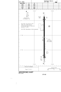
Runways:
| RWY identifier | QFU | Length (ft) | Width (ft) | Surface | LDA (ft) |
| 17 | 180° | 6890 | 148 | ASPH | 6890 |
| 35 | 0° | 6890 | 148 | ASPH | 6890 |
Airport contact information
Address: Fort Mackay Canada