

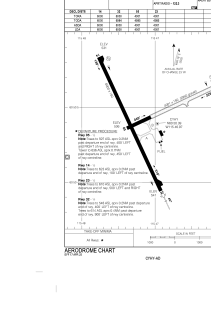


CYHY - Merlyn Carter Airport
Located in Hay River, Canada
ICAO - CYHY, IATA - YHY
Data provided by AirmateGeneral information
Coordinates: N60°50'23" W115°46'58"
Elevation is 541 feet MSL.
Magnetic variation is 16.0756° East View others Airports in Northwest Territories
Operational data
Special qualification required
Current time UTC:
Current local time:
Communications frequencies: [VIEW]
Runways:
| RWY identifier | QFU | Length (ft) | Width (ft) | Surface | LDA (ft) |
| 05 | 65° | 4001 | 150 | GRAVE | 4001 |
| 23 | 245° | 4001 | 150 | GRAVE | 4001 |
| 14 | 155° | 6000 | 150 | ASPH | 6000 |
| 32 | 335° | 6000 | 150 | ASPH | 6000 |
Airport contact information
Address: Hay River Canada