

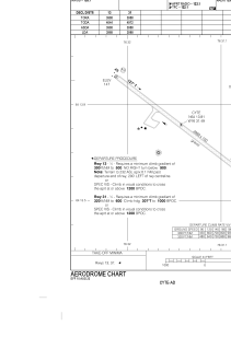


CYTE - Kinngait Airport
Located in Cape Dorset, Canada
ICAO - CYTE, IATA - YTE
Data provided by AirmateGeneral information
Coordinates: N64°13'49" W76°31'30"
Elevation is 158 feet MSL.
Magnetic variation is -22.2911° East View others Airports in Nunavut
Operational data
Special qualification required
Current time UTC:
Current local time:
Communications frequencies: [VIEW]
Runways:
| RWY identifier | QFU | Length (ft) | Width (ft) | Surface | LDA (ft) |
| 13 | 127° | 3988 | 100 | GRAVE | 3988 |
| 31 | 307° | 3988 | 100 | GRAVE | 3988 |
Airport contact information
Address: Cape Dorset Canada