
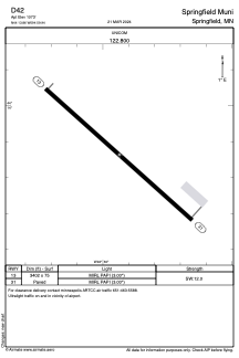


D42 - Springfield Muni
Located in Springfield, United States
ICAO - D42, IATA -
Data provided by AirmateGeneral information
Coordinates: N44°13'52" W94°59'56"
Elevation is 1073 feet MSL.
Magnetic variation is 02° East View others Airports in Minnesota
Operational data
Special qualification required
Current time UTC:
Current local time:
Communications frequencies: [VIEW]
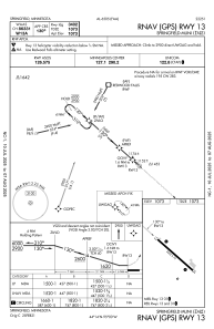
Runways:
| RWY identifier | QFU | Length (ft) | Width (ft) | Surface | LDA (ft) |
| 13 | 132° | 3402 | 75 | ASPH | |
| 31 | 312° | 3402 | 75 | ASPH |
Airport contact information
Address: Springfield United States