
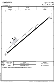


KAAS - Taylor County
Located in Campbellsville, United States
ICAO - AAS, IATA -
Data provided by AirmateGeneral information
Coordinates: N37°21'30" W85°18'34"
Elevation is 921 feet MSL.
Magnetic variation is -05° East View others Airports in Kentucky
Operational data
Special qualification required
Current time UTC:
Current local time:
Communications frequencies: [VIEW]
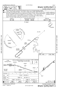
Runways:
| RWY identifier | QFU | Length (ft) | Width (ft) | Surface | LDA (ft) |
| 05 | 50° | 5004 | 75 | ASPH | |
| 23 | 230° | 5004 | 75 | ASPH |
Airport contact information
Address: Campbellsville United States