


KABY - Southwest Georgia Rgnl
Located in Albany, United States
ICAO - ABY, IATA - ABY
Data provided by AirmateGeneral information
Coordinates: N31°32'8" W84°11'40"
Elevation is 196 feet MSL.
Magnetic variation is -05° East View others Airports in Georgia
Operational data
Special qualification required
Current time UTC:
Current local time:
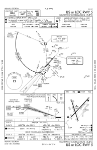
Communications frequencies: [VIEW]
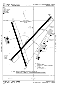
Runways:
| RWY identifier | QFU | Length (ft) | Width (ft) | Surface | LDA (ft) |
| 05 | 42° | 6601 | 148 | ASPH | 6601 |
| 23 | 222° | 6601 | 148 | ASPH | 6601 |
| 17 | 162° | 5219 | 148 | ASPH | |
| 35 | 342° | 5219 | 148 | ASPH |
Airport contact information
Address: Albany United States