
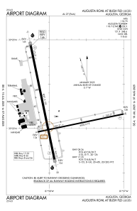


KAGS - Augusta Rgnl At Bush Fld
Located in Augusta, United States
ICAO - AGS, IATA - AGS
Data provided by AirmateGeneral information
Coordinates: N33°22'12" W81°57'52"
Elevation is 145 feet MSL.
Magnetic variation is -04° East View others Airports in Georgia
Operational data
Special qualification required
Current time UTC:
Current local time:
Communications frequencies: [VIEW]
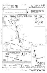
Runways:
| RWY identifier | QFU | Length (ft) | Width (ft) | Surface | LDA (ft) |
| 08 | 78° | 6002 | 75 | ASPH | |
| 26 | 258° | 6002 | 75 | ASPH | |
| 17 | 168° | 8001 | 150 | CONC | |
| 35 | 348° | 8001 | 150 | CONC |
Airport contact information
Address: Augusta United States
