
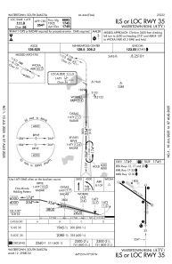
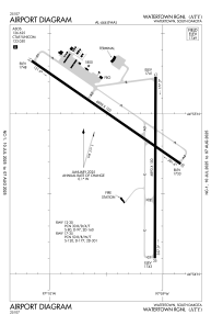


KATY - Watertown Rgnl
Located in Watertown, United States
ICAO - ATY, IATA - ATY
Data provided by AirmateGeneral information
Coordinates: N44°54'50" W97°9'17"
Elevation is 1749 feet MSL.
Magnetic variation is 06° East View others Airports in South Dakota
Operational data
Special qualification required
Current time UTC:
Current local time:
Communications frequencies: [VIEW]
Runways:
| RWY identifier | QFU | Length (ft) | Width (ft) | Surface | LDA (ft) |
| 12 | 125° | 6898 | 100 | CONC | 6899 |
| 30 | 305° | 6898 | 100 | CONC | 6899 |
| 17 | 180° | 6893 | 100 | CONC | 6894 |
| 35 | 0° | 6893 | 100 | CONC | 6894 |
Airport contact information
Address: Watertown United States