


KBIH - Bishop
Located in Bishop, United States
ICAO - BIH, IATA - BIH
Data provided by AirmateGeneral information
Coordinates: N37°22'23" W118°21'49"
Elevation is 4124 feet MSL.
Magnetic variation is 15° East View others Airports in California
Operational data
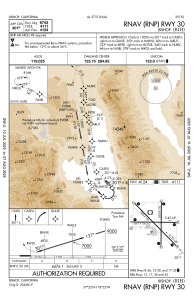
Special qualification required
Current time UTC:
Current local time:
Communications frequencies: [VIEW]
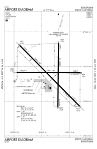
Runways:
| RWY identifier | QFU | Length (ft) | Width (ft) | Surface | LDA (ft) |
| 08 | 90° | 5567 | 100 | ASPH | |
| 26 | 270° | 5567 | 100 | ASPH | |
| 12 | 135° | 7498 | 100 | ASPH | 7098 |
| 30 | 315° | 7498 | 100 | ASPH | 6743 |
| 17 | 180° | 5600 | 100 | ASPH | |
| 35 | 0° | 5600 | 100 | ASPH | |
| H1 | 0° | 0 | 0 | UNK | |
| H2 | 0° | 0 | 0 | UNK |
Airport contact information
Address: Bishop United States