


KBTF - Skypark
Located in Bountiful, United States
ICAO - BTF, IATA - BTF
Data provided by AirmateGeneral information
Coordinates: N40°52'5" W111°55'39"
Elevation is 4237 feet MSL.
Magnetic variation is 15° East View others Airports in Utah
Operational data
Special qualification required
Current time UTC:
Current local time:
Communications frequencies: [VIEW]
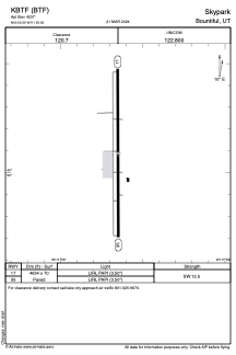
Runways:
| RWY identifier | QFU | Length (ft) | Width (ft) | Surface | LDA (ft) |
| 17 | 0° | 4634 | 70 | ASPH | |
| 35 | 0° | 4634 | 70 | ASPH |
Airport contact information
Address: Bountiful United States
