
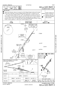
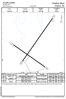


KCDR - Chadron Muni
Located in Chadron, United States
ICAO - CDR, IATA - CDR
Data provided by AirmateGeneral information
Coordinates: N42°50'15" W103°5'43"
Elevation is 3297 feet MSL.
Magnetic variation is 07° East View others Airports in Nebraska
Operational data
Special qualification required
Current time UTC:
Current local time:
Communications frequencies: [VIEW]
Runways:
| RWY identifier | QFU | Length (ft) | Width (ft) | Surface | LDA (ft) |
| 03 | 35° | 5998 | 100 | CONC | 5211 |
| 21 | 215° | 5998 | 100 | CONC | 5500 |
| 12 | 125° | 4400 | 75 | CONC | 4400 |
| 30 | 305° | 4400 | 75 | CONC | 4400 |
Airport contact information
Address: Chadron United States