
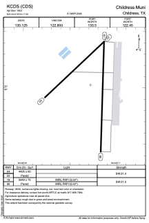


KCDS - Childress Muni
Located in Childress, United States
ICAO - CDS, IATA - CDS
Data provided by AirmateGeneral information
Coordinates: N34°26'2" W100°17'17"
Elevation is 1953 feet MSL.
Magnetic variation is 06° East View others Airports in Texas
Operational data
Special qualification required
Current time UTC:
Current local time:
Communications frequencies: [VIEW]
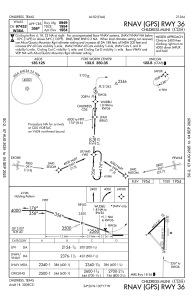
Runways:
| RWY identifier | QFU | Length (ft) | Width (ft) | Surface | LDA (ft) |
| 04 | 47° | 4425 | 60 | ASPH | |
| 22 | 227° | 4425 | 60 | ASPH | |
| 18 | 182° | 5949 | 75 | ASPH | |
| 36 | 2° | 5949 | 75 | ASPH |
Airport contact information
Address: Childress United States