
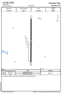


KCQB - Chandler Rgnl
Located in Chandler, United States
ICAO - CQB, IATA -
Data provided by AirmateGeneral information
Coordinates: N35°43'27" W96°49'13"
Elevation is 985 feet MSL.
Magnetic variation is 06° East View others Airports in Oklahoma
Operational data
Special qualification required
Current time UTC:
Current local time:
Communications frequencies: [VIEW]
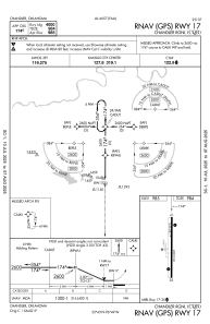
Runways:
| RWY identifier | QFU | Length (ft) | Width (ft) | Surface | LDA (ft) |
| 17 | 180° | 4000 | 60 | ASPH | |
| 35 | 360° | 4000 | 60 | ASPH |
Airport contact information
Address: Chandler United States