
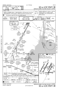
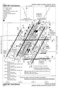


KDTW - Detroit Metro Wayne County
Located in Detroit, United States
ICAO - DTW, IATA - DTW
Data provided by AirmateGeneral information
Coordinates: N42°12'45" W83°21'12"
Elevation is 645 feet MSL.
Magnetic variation is -07° East View others Airports in Michigan
Operational data
Special qualification required
Current time UTC:
Current local time:
Communications frequencies: [VIEW]
Runways:
| RWY identifier | QFU | Length (ft) | Width (ft) | Surface | LDA (ft) |
| 03L | 29° | 8501 | 150 | CONC | 8501 |
| 21R | 209° | 8501 | 150 | CONC | 8501 |
| 03R | 29° | 10001 | 150 | CONC | 10001 |
| 21L | 209° | 10001 | 150 | CONC | 10001 |
| 04L | 29° | 10000 | 150 | CONC | 10000 |
| 22R | 209° | 10000 | 150 | CONC | 10000 |
| 04R | 29° | 12003 | 200 | CONC | 11494 |
| 22L | 209° | 12003 | 200 | CONC | 12003 |
| 04X | 29° | 0 | 0 | ||
| 22X | 209° | 0 | 0 | ||
| 09L | 89° | 8708 | 150 | CONC | 8618 |
| 27R | 269° | 8708 | 150 | CONC | 8708 |
| 09R | 89° | 8500 | 150 | CONC | 8500 |
| 27L | 269° | 8500 | 150 | CONC | 8500 |
Airport contact information
Address: Detroit United States