


KEND - Vance Afb
Located in Enid, United States
ICAO - END, IATA - END
Data provided by AirmateGeneral information
Coordinates: N36°20'23" W97°55'2"
Elevation is 1312 feet MSL.
Magnetic variation is 05° East View others Airports in Oklahoma
Operational data
Special qualification required
Current time UTC:
Current local time:
Communications frequencies: [VIEW]
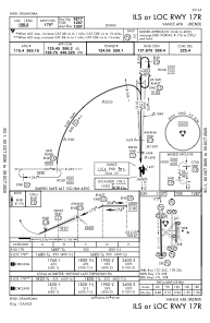
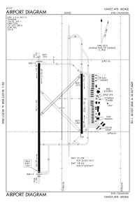
Runways:
| RWY identifier | QFU | Length (ft) | Width (ft) | Surface | LDA (ft) |
| 17C | 180° | 9217 | 150 | OTHER | |
| 35C | 360° | 9217 | 150 | OTHER | |
| 17L | 180° | 5024 | 150 | CONC | |
| 35R | 360° | 5024 | 150 | CONC | |
| 17R | 180° | 9217 | 150 | CONC | |
| 35L | 360° | 9217 | 150 | CONC |
Airport contact information
Address: Enid United States