


KGBD - Great Bend Muni
Located in Great Bend, United States
ICAO - GBD, IATA - GBD
Data provided by AirmateGeneral information
Coordinates: N38°20'39" W98°51'33"
Elevation is 1886 feet MSL.
Magnetic variation is 08° East View others Airports in Kansas
Operational data
Special qualification required
Current time UTC:
Current local time:
Communications frequencies: [VIEW]
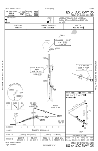
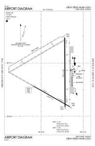
Runways:
| RWY identifier | QFU | Length (ft) | Width (ft) | Surface | LDA (ft) |
| 11 | 120° | 4706 | 75 | ASPH | 4706 |
| 29 | 300° | 4706 | 75 | ASPH | 4706 |
| 17 | 180° | 7852 | 100 | CONC | 7852 |
| 35 | 360° | 7852 | 100 | CONC | 7852 |
Airport contact information
Address: Great Bend United States
