
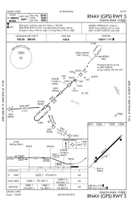
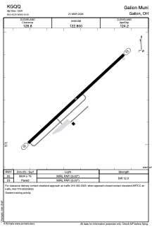


KGQQ - Galion Muni
Located in Galion, United States
ICAO - GQQ, IATA - GQQ
Data provided by AirmateGeneral information
Coordinates: N40°45'12" W82°43'26"
Elevation is 1224 feet MSL.
Magnetic variation is -07° East View others Airports in Ohio
Operational data
Special qualification required
Current time UTC:
Current local time:
Communications frequencies: [VIEW]
Runways:
| RWY identifier | QFU | Length (ft) | Width (ft) | Surface | LDA (ft) |
| 05 | 47° | 3504 | 75 | ASPH | |
| 23 | 227° | 3504 | 75 | ASPH |
Airport contact information
Address: Galion United States
