
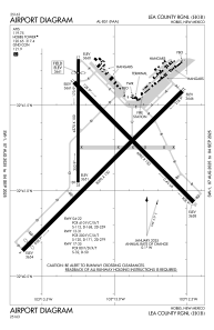


KHOB - Lea County Rgnl
Located in Hobbs, United States
ICAO - HOB, IATA - HOB
Data provided by AirmateGeneral information
Coordinates: N32°41'14" W103°13'3"
Elevation is 3660 feet MSL.
Magnetic variation is 07° East View others Airports in New Mexico
Operational data
Special qualification required
Current time UTC:
Current local time:
Communications frequencies: [VIEW]
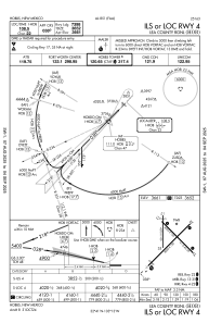
Runways:
| RWY identifier | QFU | Length (ft) | Width (ft) | Surface | LDA (ft) |
| 04 | 45° | 8000 | 150 | ASPH | 7398 |
| 22 | 225° | 8000 | 150 | ASPH | 8000 |
| 13 | 135° | 6002 | 150 | ASPH | 6002 |
| 31 | 315° | 6002 | 150 | ASPH | 6002 |
| 17 | 180° | 4370 | 100 | ASPH | 3878 |
| 35 | 0° | 4370 | 100 | ASPH | 3878 |
Airport contact information
Address: Hobbs United States