
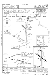
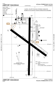


KHUM - Houma-Terrebonne
Located in Houma, United States
ICAO - HUM, IATA - HUM
Data provided by AirmateGeneral information
Coordinates: N29°33'59" W90°39'38"
Elevation is 8 feet MSL.
Magnetic variation is 01° East View others Airports in Louisiana
Operational data
Special qualification required
Current time UTC:
Current local time:
Communications frequencies: [VIEW]
Runways:
| RWY identifier | QFU | Length (ft) | Width (ft) | Surface | LDA (ft) |
| 12 | 125° | 4999 | 185 | CONC | 4843 |
| 30 | 305° | 4999 | 185 | CONC | 4999 |
| 18 | 180° | 6509 | 150 | CONC | 6413 |
| 36 | 0° | 6509 | 150 | CONC | 6508 |
Airport contact information
Address: Houma United States


