


KIAB - Mc Connell Afb
Located in Wichita, United States
ICAO - IAB, IATA - IAB
Data provided by AirmateGeneral information
Coordinates: N37°37'23" W97°16'3"
Elevation is 1371 feet MSL.
Magnetic variation is 04° East View others Airports in Kansas
Operational data
Special qualification required
Current time UTC:
Current local time:
Communications frequencies: [VIEW]
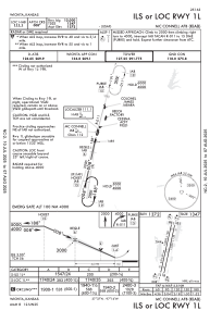
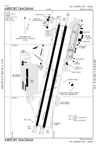
Runways:
| RWY identifier | QFU | Length (ft) | Width (ft) | Surface | LDA (ft) |
| 01L | 12° | 12000 | 150 | OTHER | |
| 19R | 192° | 12000 | 150 | OTHER | |
| 01R | 12° | 12007 | 150 | ASPH | |
| 19L | 192° | 12007 | 150 | ASPH |
Airport contact information
Address: Wichita United States