


KJEF - Jefferson City Meml
Located in Jefferson City, United States
ICAO - JEF, IATA - JEF
Data provided by AirmateGeneral information
Coordinates: N38°35'28" W92°9'22"
Elevation is 549 feet MSL.
Magnetic variation is -01° East View others Airports in Missouri
Operational data
Special qualification required
Current time UTC:
Current local time:
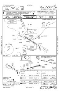
Communications frequencies: [VIEW]
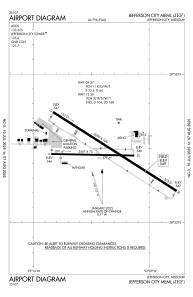
Runways:
| RWY identifier | QFU | Length (ft) | Width (ft) | Surface | LDA (ft) |
| 09 | 91° | 3401 | 75 | CONC | |
| 27 | 271° | 3401 | 75 | CONC | |
| 12 | 123° | 6000 | 100 | CONC | |
| 30 | 303° | 6000 | 100 | CONC |
Airport contact information
Address: Jefferson City United States
