
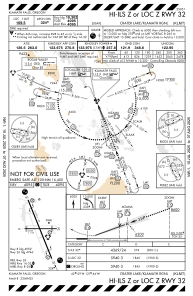
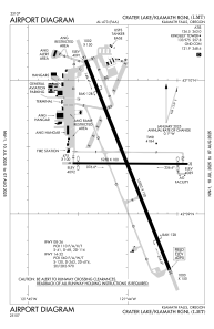


KLMT - Crater Lake/Klamath Rgnl
Located in Klamath Falls, United States
ICAO - LMT, IATA - LMT
Data provided by AirmateGeneral information
Coordinates: N42°9'22" W121°43'60"
Elevation is 4095 feet MSL.
Magnetic variation is 14° East View others Airports in Oregon
Operational data
Special qualification required
Current time UTC:
Current local time:
Communications frequencies: [VIEW]
Runways:
| RWY identifier | QFU | Length (ft) | Width (ft) | Surface | LDA (ft) |
| 08 | 90° | 5258 | 100 | ASPH | 4952 |
| 26 | 270° | 5258 | 100 | ASPH | 4746 |
| 14 | 158° | 10302 | 150 | OTHER | 10302 |
| 32 | 338° | 10302 | 150 | OTHER | 10302 |
Airport contact information
Address: Klamath Falls United States
