


KLWS - Lewiston/Nez Perce County
Located in Lewiston, United States
ICAO - LWS, IATA - LWS
Data provided by AirmateGeneral information
Coordinates: N46°22'28" W117°0'55"
Elevation is 1442 feet MSL.
Magnetic variation is 15° East View others Airports in Idaho
Operational data
Special qualification required
Current time UTC:
Current local time:
Communications frequencies: [VIEW]
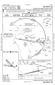
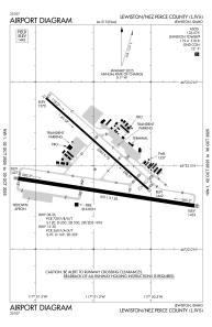
Runways:
| RWY identifier | QFU | Length (ft) | Width (ft) | Surface | LDA (ft) |
| 08 | 99° | 6511 | 150 | ASPH | 6511 |
| 26 | 279° | 6511 | 150 | ASPH | 6511 |
| 12 | 132° | 5003 | 75 | ASPH | 4750 |
| 30 | 312° | 5003 | 75 | ASPH | 4750 |
Airport contact information
Address: Lewiston United States
