
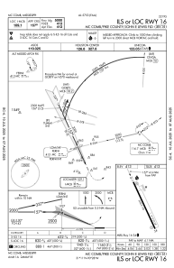
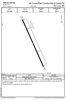


KMCB - Mc Comb/Pike County/John E Lewis Fld
Located in Mc Comb, United States
ICAO - MCB, IATA - MCB
Data provided by AirmateGeneral information
Coordinates: N31°10'42" W90°28'19"
Elevation is 413 feet MSL.
Magnetic variation is -01° East View others Airports in Mississippi
Operational data
Special qualification required
Current time UTC:
Current local time:
Communications frequencies: [VIEW]
Runways:
| RWY identifier | QFU | Length (ft) | Width (ft) | Surface | LDA (ft) |
| 16 | 156° | 5000 | 100 | ASPH | |
| 34 | 336° | 5000 | 100 | ASPH |
Airport contact information
Address: Mc Comb United States