
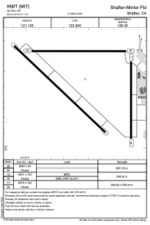


KMIT - Shafter-Minter Fld
Located in Shafter, United States
ICAO - MIT, IATA -
Data provided by AirmateGeneral information
Coordinates: N35°30'27" W119°11'32"
Elevation is 424 feet MSL.
Magnetic variation is 13° East View others Airports in California
Operational data
Special qualification required
Current time UTC:
Current local time:
Communications frequencies: [VIEW]
Runways:
| RWY identifier | QFU | Length (ft) | Width (ft) | Surface | LDA (ft) |
| 08 | 90° | 3680 | 60 | ASPH | |
| 26 | 270° | 3680 | 60 | ASPH | |
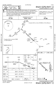
| 12 | 133° | 4501 | 100 | ASPH | |
| 30 | 313° | 4501 | 100 | ASPH | |
| 17 | 180° | 2972 | 100 | CONC | |
| 35 | 0° | 2972 | 100 | CONC |
Airport contact information
Address: Shafter United States