
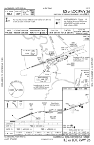
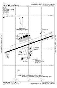


KMRB - Eastern Wv Rgnl/Shepherd Fld
Located in Martinsburg, United States
ICAO - MRB, IATA - MRB
Data provided by AirmateGeneral information
Coordinates: N39°24'8" W77°58'59"
Elevation is 564 feet MSL.
Magnetic variation is -08° East View others Airports in West Virginia
Operational data
Special qualification required
Current time UTC:
Current local time:
Communications frequencies: [VIEW]
Runways:
| RWY identifier | QFU | Length (ft) | Width (ft) | Surface | LDA (ft) |
| 08 | 71° | 8815 | 150 | OTHER | 8215 |
| 26 | 251° | 8815 | 150 | OTHER | 7815 |
Airport contact information
Address: Martinsburg United States
