


KMUO - Mountain Home Afb
Located in Mountain Home, United States
ICAO - MUO, IATA -
Data provided by AirmateGeneral information
Coordinates: N43°2'37" W115°52'21"
Elevation is 2996 feet MSL.
Magnetic variation is 13° East View others Airports in Idaho
Operational data
Special qualification required
Current time UTC:
Current local time:
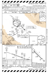
Communications frequencies: [VIEW]
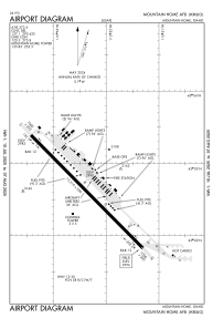
Runways:
| RWY identifier | QFU | Length (ft) | Width (ft) | Surface | LDA (ft) |
| 12 | 135° | 13510 | 200 | OTHER | |
| 30 | 315° | 13510 | 200 | OTHER |
Airport contact information
Address: Mountain Home United States