


KOGB - Orangeburg Muni
Located in Orangeburg, United States
ICAO - OGB, IATA -
Data provided by AirmateGeneral information
Coordinates: N33°27'25" W80°51'34"
Elevation is 195 feet MSL.
Magnetic variation is -07° East View others Airports in South Carolina
Operational data
Special qualification required
Current time UTC:
Current local time:
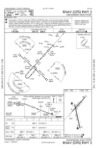
Communications frequencies: [VIEW]
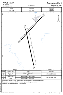
Runways:
| RWY identifier | QFU | Length (ft) | Width (ft) | Surface | LDA (ft) |
| 05 | 42° | 4508 | 100 | ASPH | |
| 23 | 222° | 4508 | 100 | ASPH | |
| 17 | 167° | 5399 | 100 | ASPH | |
| 35 | 347° | 5399 | 100 | ASPH |
Airport contact information
Address: Orangeburg United States