
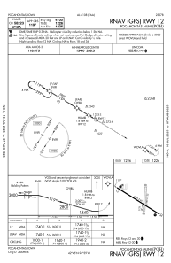


KPOH - Pocahontas Muni
Located in Pocahontas, United States
ICAO - POH, IATA -
Data provided by AirmateGeneral information
Coordinates: N42°44'34" W94°38'50"
Elevation is 1225 feet MSL.
Magnetic variation is 02° East View others Airports in Iowa
Operational data
Special qualification required
Current time UTC:
Current local time:
Communications frequencies: [VIEW]
Runways:
| RWY identifier | QFU | Length (ft) | Width (ft) | Surface | LDA (ft) |
| 12 | 121° | 4100 | 60 | ASPH | |
| 30 | 301° | 4100 | 60 | ASPH | |
| 18 | 184° | 1999 | 135 | GRASS | |
| 36 | 4° | 1999 | 135 | GRASS |
Airport contact information
Address: Pocahontas United States