


KRHI - Rhinelander/Oneida County
Located in Rhinelander, United States
ICAO - RHI, IATA - RHI
Data provided by AirmateGeneral information
Coordinates: N45°37'51" W89°27'60"
Elevation is 1623 feet MSL.
Magnetic variation is -03° East View others Airports in Wisconsin
Operational data
Special qualification required
Current time UTC:
Current local time:
Communications frequencies: [VIEW]
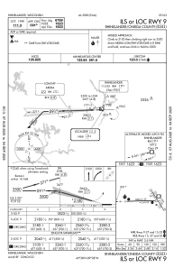
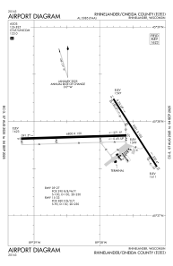
Runways:
| RWY identifier | QFU | Length (ft) | Width (ft) | Surface | LDA (ft) |
| 09 | 88° | 6800 | 150 | CONC | 6799 |
| 27 | 268° | 6800 | 150 | CONC | 6799 |
| 15 | 147° | 5201 | 100 | ASPH | 5201 |
| 33 | 327° | 5201 | 100 | ASPH | 5201 |
Airport contact information
Address: Rhinelander United States
