


KSKF - Kelly Fld
Located in San Antonio, United States
ICAO - SKF, IATA - SKF
Data provided by AirmateGeneral information
Coordinates: N29°23'3" W98°34'52"
Elevation is 690 feet MSL.
Magnetic variation is 04° East View others Airports in Texas
Operational data
Special qualification required
Current time UTC:
Current local time:
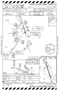
Communications frequencies: [VIEW]
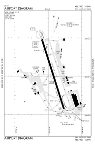
Runways:
| RWY identifier | QFU | Length (ft) | Width (ft) | Surface | LDA (ft) |
| 16 | 162° | 11550 | 150 | CONC | |
| 34 | 342° | 11550 | 150 | CONC |
Airport contact information
Address: San Antonio United States