
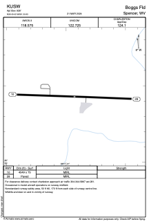


KUSW - Boggs Fld
Located in Spencer, United States
ICAO - USW, IATA -
Data provided by AirmateGeneral information
Coordinates: N38°49'26" W81°20'56"
Elevation is 928 feet MSL.
Magnetic variation is -08° East View others Airports in West Virginia
Operational data
Special qualification required
Current time UTC:
Current local time:
Communications frequencies: [VIEW]
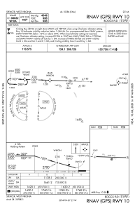
Runways:
| RWY identifier | QFU | Length (ft) | Width (ft) | Surface | LDA (ft) |
| 10 | 92° | 4549 | 75 | ASPH | |
| 28 | 272° | 4549 | 75 | ASPH |
Airport contact information
Address: Spencer United States