
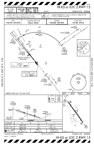
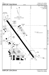


KWRB - Robins Afb
Located in Warner Robins, United States
ICAO - WRB, IATA - WRB
Data provided by AirmateGeneral information
Coordinates: N32°38'25" W83°35'31"
Elevation is 294 feet MSL.
Magnetic variation is -02° East View others Airports in Georgia
Operational data
Special qualification required
Current time UTC:
Current local time:
Communications frequencies: [VIEW]
Runways:
| RWY identifier | QFU | Length (ft) | Width (ft) | Surface | LDA (ft) |
| 15 | 144° | 12001 | 300 | OTHER | |
| 33 | 324° | 12001 | 300 | OTHER |
Airport contact information
Address: Warner Robins United States