
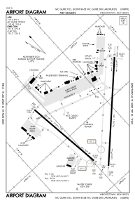


KWRI - Mc Guire Fld (Joint Base Mc Guire Dix Lakehurst)
Located in Wrightstown, United States
ICAO - WRI, IATA - WRI
Data provided by AirmateGeneral information
Coordinates: N40°0'56" W74°35'30"
Elevation is 140 feet MSL.
Magnetic variation is -12° East View others Airports in New Jersey
Operational data
Special qualification required
Current time UTC:
Current local time:
Communications frequencies: [VIEW]
Runways:
| RWY identifier | QFU | Length (ft) | Width (ft) | Surface | LDA (ft) |
| 06 | 45° | 10014 | 150 | OTHER | |
| 24 | 225° | 10014 | 150 | OTHER | |
| 18 | 173° | 7126 | 150 | CONC | |
| 36 | 353° | 7126 | 150 | CONC |
Airport contact information
Address: Wrightstown United States