


L78 - Jacumba
Located in Jacumba, United States
ICAO - L78, IATA -
Data provided by AirmateGeneral information
Coordinates: N32°36'57" W116°9'56"
Elevation is 2844 feet MSL.
Magnetic variation is 13° East View others Airports in California
Operational data
Special qualification required
Current time UTC:
Current local time:
Communications frequencies: [VIEW]
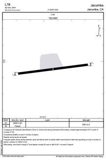
Runways:
| RWY identifier | QFU | Length (ft) | Width (ft) | Surface | LDA (ft) |
| 07 | 0° | 2562 | 60 | ASPH | |
| 25 | 0° | 2562 | 60 | ASPH |
Airport contact information
Address: Jacumba United States