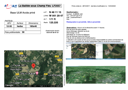


LF3557 - La Baillée sous Champ Fleu
Located in Liffré, France
ICAO - , IATA -
Data provided by AirmateGeneral information
Coordinates: N48°11'15" W1°29'47"
Elevation is 171 feet MSL.
View others Airports in Brittany
Operational data
Special qualification required
Current time UTC:
Current local time:
Communications frequencies: [VIEW]
Runways:
| RWY identifier | QFU | Length (ft) | Width (ft) | Surface | LDA (ft) |
| 12 | 0° | 590 | 131 | GRASS | |
| 30 | 0° | 590 | 131 | GRASS |
Airport contact information
Address: Liffré France