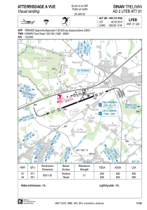


LFEB - Dinan Trelivan
Located in Dinan, France
ICAO - LFEB, IATA -
Data provided by AirmateGeneral information
Coordinates: N48°26'36" W2°6'12"
Elevation is 393 feet MSL.
Magnetic variation is -0.35° East View others Airports in Brittany
Operational data
Special qualification required
Current time UTC:
Current local time:
Communications frequencies: [VIEW]
Runways:
| RWY identifier | QFU | Length (ft) | Width (ft) | Surface | LDA (ft) |
| 07 | 70° | 2723 | 98 | ASPH | |
| 25 | 250° | 2723 | 98 | ASPH |
Airport contact information
Address: Dinan France