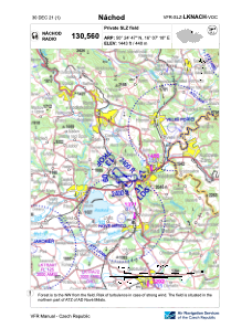


LKNACH - Nachod
Located in Náchod, Czech Republic
ICAO - , IATA -
Data provided by AirmateGeneral information
Coordinates: N50°24'47" E16°7'18"
Elevation is 1443 feet MSL.
View others Airports in Hradec Králové Region
Operational data
Special qualification required
Current time UTC:
Current local time:
Communications frequencies: [VIEW]
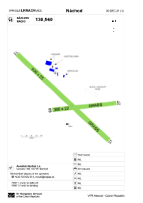
Runways:
| RWY identifier | QFU | Length (ft) | Width (ft) | Surface | LDA (ft) |
| 09 | 84° | 1181 | 72 | GRASS | 1181 |
| 27 | 264° | 1181 | 72 | GRASS | 1181 |
| 13 | 134° | 2067 | 82 | GRASS | |
| 31 | 314° | 2067 | 82 | GRASS | 2067 |
Airport contact information
Address: Náchod Czech Republic