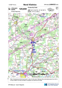

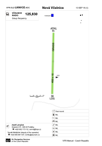


LKNVCE - Nova Vcelnice
Located in Nová Včelnice, Czech Republic
ICAO - , IATA -
Data provided by AirmateGeneral information
Coordinates: N49°16'2" E15°4'40"
Elevation is 1771 feet MSL.
View others Airports in South Bohemian Region
Operational data
Special qualification required
Current time UTC:
Current local time:
Weather at : LKNA - Namest ( 77 km )
METAR: LKNA 062230Z VRB02KT CAVOK 14/06 Q1024 RMK BLACK
TAF: TAF LKNA 061700Z 0618/0718 30007KT CAVOK BECMG 0618/0620 05004KT TEMPO 0700/0705 09006KT BECMG 0705/0707 13012KT TEMPO 0710/0718 15017KT SCT045
Communications frequencies: [VIEW]
Runways:
| RWY identifier | QFU | Length (ft) | Width (ft) | Surface | LDA (ft) |
| 18 | 1° | 1476 | 49 | GRASS | |
| 36 | 181° | 1476 | 49 | GRASS | 1476 |
Airport contact information
Address: Nová Včelnice Czech Republic