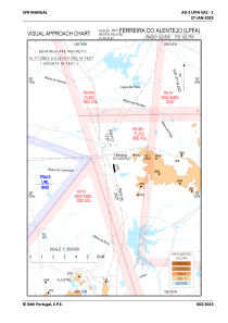

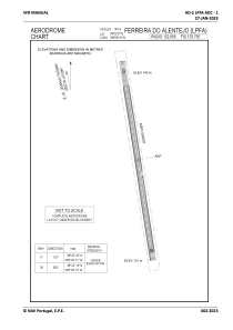


LPFA - Ferreira Do Alentejo
Located in Ferreira Do Alentejo, Portugal
ICAO - , IATA -
Data provided by AirmateGeneral information
Coordinates: N38°2'21" W8°6'15"
Elevation is 459 feet MSL.
Magnetic variation is -001.1200° East View others Airports in Portalegre District
Operational data
Special qualification required
Current time UTC:
Current local time:
Communications frequencies: [VIEW]
Runways:
| RWY identifier | QFU | Length (ft) | Width (ft) | Surface | LDA (ft) |
| 17 | 0° | 1834 | 66 | UNK | |
| 35 | 0° | 1834 | 66 | UNK |
Airport contact information
Address: Ferreira Do Alentejo Portugal