
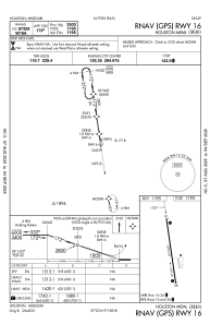
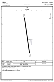


M48 - Houston Meml
Located in Houston, United States
ICAO - M48, IATA -
Data provided by AirmateGeneral information
Coordinates: N37°19'49" W91°58'23"
Elevation is 1195 feet MSL.
Magnetic variation is 00° East View others Airports in Missouri
Operational data
Special qualification required
Current time UTC:
Current local time:
Communications frequencies: [VIEW]
Runways:
| RWY identifier | QFU | Length (ft) | Width (ft) | Surface | LDA (ft) |
| 16 | 172° | 3500 | 60 | CONC | |
| 34 | 352° | 3500 | 60 | CONC |
Airport contact information
Address: Houston United States